Identifying Camera Trap Locations to Monitor Grizzly Bear (Ursus arctos horribilis) Populations in the North Cascades Ecosystem
Figure 2
Figure 3
Grizzly bears (Ursus arctos horribilis) historically occurred throughout the North Cascades Ecosystem (NCE), but due to pressures from human activity including hunting and habitat modification, the population has declined. It is estimated that less than 10 grizzly bears remain in the Washington portion of the NCE (DOI, 2017), despite sufficient habitat. In January 2017 the U.S. Department of the Interior (DOI), the National Park Service (NPS), and the U.S. Fish and Wildlife Service (FWS) released a draft grizzly bear restoration plan detailing a proposed course of action to recover the grizzly bear population in the NCE by relocating bears from other viable populations.
Given the grizzly bear restoration plan, the purpose of this project is to identify ideal locations for camera traps in the NCE. Camera traps are a relatively noninvasive data collection method in wildlife studies, requiring no capture or handling of animals (Ancrenaz et al, 2012). Locations will be determined by first identifying ideal grizzly bear habitat, and then determining which areas of that habitat would be reasonably accessible to researchers.
Introduction
Figure 1
The habitat analysis for the 6.1 million acre Grizzly Bear Recovery Zone (GBRZ) involved human use variables and preferred grizzly bear landcover in the late season, July 15 – September 20, when more habitat would be accessible to researchers.
Bear Management Units (Cascadia Partnership Forum, 2014) were ranked by total road length, since more roads mean more habitat fragmentation. In Figure 1, red indicates units with more roads and green indicates units with fewer roads. A land cover raster (Kiilsgaard and Barrett, 1999) was clipped to the GBRZ and ranked by appropriateness of habitat, as shown in Table 1 with the classification range. Buffers for human use and non-habitat variables and classifications appear in Table 2. Raster calculator was used to identify grizzly bear habitat in the GBRZ, which appears in a red to green gradient in Figure 2. For the camera location analysis, raster cells with the top three scores were exported to polygons. Polygons within 800m of trails were selected to determine accessible habitat areas for researchers to hike to and identify locations for camera trap placement.
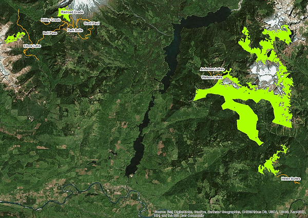
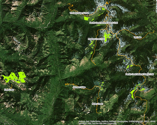
The top ranking habitat areas within 800m of a trail appear in Figure 3. Detailed images of select habitat areas with trails (orange) and their corresponding names, as well as roads (pink) appear in Figures 4-6. Figure 4 shows accessible habitat near the Upper Cascade River watershed, where the last confirmed grizzly bear sighting occurred in Washington State in 2010 (Zimmer, 2011). Figure 5 shows accessible habitat near the Glacier Peak Wilderness, where a grizzly bear was sighted in 1996 (DOI, 2017). Figure 6 shows accessible habitat just east of Thunder Creek, where a grizzly bear track was confirmed in 1991 (WWO, 2017) and north of upper Lake Chelan where a female and cub were seen in 1991 (DOI, 2017).
Method
Results
Figure 4
Click to download poster


© Aaron Wilson 2016
https://www.nationalparks.org/connect/park-experience/north-cascades-rugged-mountain-paradise
Fisher Creek Basin, potential grizzly bear habitat.


Figure 5
Figure 6
Additional Map Images


Discussion
The results of this analysis indicate that there are several core areas of ideal grizzly bear habitat throughout the GBRZ that are appropriate and accessible for camera trap placement. Future analyses may incorporate canopy cover or avalanche chute data, and may also consider options for early season camera placement to gather data on grizzly bear behavior and spatial use at the end of hibernation.
Ancrenaz, M., Hearn, A. J., Ross, J., Sollmann, R., & Wilting, A. (2012). Handbook for wildlife monitoring using camera-traps. Sabah, Malaysia: BBEC II Secretariat.
Chetkiewicz, C. B. and Boyce, M. S. (2009). Use of resource selection functions to identify conservation corridors. Journal of Applied Ecology, 46, 1036-1047. doi : 10.1111/j.1365- 2664.2009.01686.x
Clevenger, A. P., Wierzchowski, J., Chruszcz, B., & Gunson, K. (2001). GIS-generated, expert-based models for identifying wildlife habitat linkages and planning mitigation passages. Conservation Biology, 16(2), 503-514.
Freilich, J. and Liang, M. (Producers), & O’Brien, D. J. (Director). (2011, January 12). Connecting with Carnivores. [Video file] Retrieved from https://vimeo.com/18710531
Lyons, A. L., Gaines, W. L., Begley, J., & Singleton, P. (2016). Grizzly bear carrying capacity in the North Cascades Ecosystem. [Report]. Seattle, WA: Skagit Environmental Endowment Commission.
Mace, R. D., Waller, J. S., Manley, T. L., Lyon, L. J., & Zuuring, H. (1996). Relationships among grizzly bears, roads and habitat in the Swan Mountains Montana. Journal of Applied Ecology, 33(6), 1395-1404.
Moskowitz, D. and Huyett, A. (2016). Grizzly bear remote camera traps: installation and monitoring protocol. Unpublished manuscript.
North Cascades Grizzly Bear Recovery Team. (2004). Recovery plan for grizzly bears in the North Cascades of British Columbia. Victoria, BC: Ministry of Water, Land and Air Protection. 60pp.
Proctor, M. F., Nielsen, S. E., Kasworm, W. F., Servheen, C., Radandt, T. G., Machutchon, A. G., & Boyce, M. S. (2015). Grizzly bear connectivity mapping in the Canada-United States trans- border region. The Journal of Wildlife Management, 79(4), 544-558. doi : 10.1002/jwmg.862
Romain-Bondi, K. A., Wielgus, R. B., Waits, L., Kasworm, W. F., Austin, M., & Wakkinen, W. (2003). Density and population size estimates for north cascade grizzly bears using DNA hair- sampling techniques. Biological Conservation, 117(2004), 417-428. doi : 10.1016/j.biocon.2003.07.005
U.S. Department of the Interior, U.S. Fish Wildlife Service, & U.S. National Parks Service. (2017). Draft grizzly bear restoration plan/environmental impact statement: North Cascades Ecosystem. Washington, D.C.: United States Department of the Interior.
U.S. Fish and Wildlife Service. (1997). North Cascades Ecosystem recovery plan chapter. In Grizzly Bear Recovery Plan.
Walter, J. S. and Servheen, C. (2005). Effects of transportation infrastructure on grizzly bears in northwestern Montana. The Journal of Wildlife Management, 69(3), 985-1000.
Western Wildlife Outreach (WWO). (2017). Grizzly sightings. Western Wildlife Outreach. http://westernwildlife.org/grizzly-bear-outreach-project/grizzly-sightings/
Wilson, A. (2016). North Cascades – a rugged mountain paradise. Retrieved May 25, 2017, from https://www.nationalparks.org/connect/park-experience/north-cascades-rugged-mountain- paradise.
Zimmer, D. (2011). North Cascades grizzly bear sighting. U.S. Fish & Wildlife Service.
References
Data Sources
Cascadia Partnership Forum. North Cascade Bear Management Units (2014).
https://databasin.org/datasets/1490988a9b784d16a36094452fe0e938
Cascadia Partnership Forum. North Cascade Grizzly Bear Recovery Zone (2014).
https://databasin.org/datasets/be633f432fb14002bf7fe02548084af7
Esri Data and Maps. USA Mountain Peaks (2010). https://www.arcgis.com/home/item.html?id=6706f7e6712b4b479dcb4fce4b7b3172
Northwest Habitat Institute and Washington Department of Fish and Wildlife. Washington Current Wildlife Habitat Types, 1:100,000, 25m (1999). http://nwhi.org/inc/data/gisdata/data/washington/wacurhab.zip
U.S. Census Bureau, Department of Commerce. TIGER/Line Shapefile, 2013, state, Washington, Primary and Secondary Roads State-based Shapefile (2013). http://www2.census.gov/geo/tiger/TIGER2013/PRISECROADS/tl_2013_53_prisecroads.zip
U.S. Geological Survey. National Land Cover Database, 30m (2011). http://www.landfire.gov/bulk/downloadfile.php?TYPE=nlcd2011&FNAME=nlcd_2011_landcover_2 011_edition_2014_10_10.zip
Washington State Department of Natural Resources. DNR Proprietary Roads (Statewide).
Washington State Department of Transportation. Railroads in Washington State, 1:24,000 (2017).
Washington Hometown. Camping – WA (2017). Via: contact@washingtonhometown.com
Washington State Recreation and Conservation Office. Trails Database (2015). http://rco.wa.gov/maps/DATA/Trails/WA_RCO_Trails_2015.gdb.zip